HISTORY
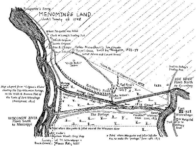
The “portage” between the Wisconsin and the Fox Rivers was used by Indians, early and unknown French explorers and fur trappers. Possibly, the first reference to this area was made by Nicolet, who might have visited this area in 1640. The first description of the “portage” came from the journals of Marquette and Joliet, who arrived at the “portage” June 14, 1673.

The land lying between the Fox River and the Wisconsin River was known as in the early days as a “portage.” A portage is the act of transporting boats and supplies from one waterway to another. It is unique as it is part of a natural water-shed or is called a “continental divide.” The Fox River flows from South to North emptying into Lake Michigan – St. Lawrence – Atlantic and the Wisconsin River flows from North to South emptying into the Mississippi – Gulf of Mexico.
The Indians called the “portage” Wau-wau-o-nah, now more commonly known as “Wauona” which means “the place where one takes up his canoe and carries it on his back.” The one and four-tenths mile trail through this marshy area was very difficult. Sometimes during high water boats could paddle from one river to the other. In 1828, the U.S. Department of Army sent soldiers to erect a fort at the Portage, to protect the white settlers and to keep the Indians in order. The Indians were charging tolls to “portage” across their land and the white settlers did not want to pay. There was a need for a better means of transportation.The Erie Canal had been constructed with much success. People began to talk of a Portage Canal. On March 7, 1834 the formation of the Portage Canal Company was approved by the Legislative Council Territory of Michigan. In 1837, a company was chartered under the name of the “Portage Canal Company,” for the purpose of constructing a canal connecting the Fox and Wisconsin Rivers.
The Company was composed of stockholders who were also the incorporators of the Shot Tower Company of Helena. They needed to be able to move their lead shot to the East more efficiently. In the year 1838, the digging of the canal was began, which was parallel to Wauona Trail. $10,000 was spent and the work was abandoned. All these workers had as tools were shovels and wheelbarrows. Nothing was done for years. Finally the General Government and the Secretary of War Poinsett called the attention of Congress to its value as a route for military communication and transportation, and urged funding for the construction of a canal and locks.
In June of 1849, a new route was chosen for the canal, which is the present one. Work progressed slowly, being delayed by misunderstandings between contractor and State. The men working were without their wages for weeks and months, and were compelled to abandon the project, leaving it in an unfinished condition. Although, in this unfinished state, canoes did make use of the canal.
Little was done on the canal until 1853. A new company was incorporated called the Fox and Wisconsin Improvement Company. The Company was supposed to complete the construction of the canal in three years. They failed to do this. This Company went into bankruptcy. Some lands were sold at a public sale at Appleton, the works and improvements and the balance of the land granted by Congress went unsold. The funds were sufficient to pay off the Company’s indebtedness. In 1854, the City passed an ordinance forbidding nude bathing in the Canal and Wisconsin River.
In 1874, the Corps of Engineers, Department of Army started at the Fox River end and completed the canal in 1876, which was 75ft. wide, 7 ft. deep, 2 1/2 miles long with a draw of 6 ft., a right of way on the Northside of 45 ft. and 75 ft. on the Southside. The first boat through the completed canal was the Boscobel, on June 30, 1876. According to the Fort Winnebago Lock Tenders book dated 1878-1908, there were many big boats through the canal, some of 300 ton capacity, as well as pleasure craft. The canal was used until 1951 when the Fort Winnebago Lock was bulldozed in and the Wisconsin River Locks welded shut. In 1961, the ownership of the canal was transferred from the Department of Army to the State Of Wisconsin.
In 1981, the state designated the Department of Natural Resources as the authority governing the canal. Little or nothing has been done by the State of Wisconsin to maintain this historic site. The Canal has been placed on the National and State Register of Historic Places through the efforts of the Portage Canal Society, Inc. In 1983, the downtown corridor between Adams Street and the Wisconsin River was restored with City of Portage and Block Grant funds. In 1987, the south bank of the canal became part of the National Ice Age Trail. Maps and more information are available at the Portage Area Chamber of Commerce, Located at the corner of Wisconsin and Cook Streets, Downtown Portage.
The above information excerpted from: “Portage Canal History” by Frederica Kleist (1983)
